|
Dramway
Route (see
also timelines)
This
information is derived in part from an SBL related webpage,
copyright
holder unknown, contact us if it's you!
Route
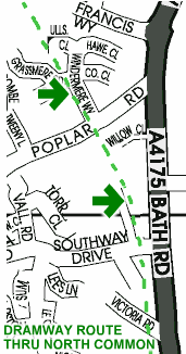
from North Common through Oldland to the Avon:
The path of the
dramway through North Common is clear to see.
| Approaching from the north
it crosses Poplar Road then passes to the side of the Bousfield Inks Factory
(lower of the two green
arrows on map)
eventually crossing Southway Drive. An industrial estate
covers the next section.
(The
2 green arrows
on this map show specific areas where
many Dramway sleepers can still be seen in
situ. The route is clearly signposted.)
Afterwards it
progresses towards the playing fields it is bounded
by hedges adjacent to the main road. It “crossed
under”
the road opposite Redfield Edge School entrance. (the Hole Lane Pit location)
Shortly afterwards
it was joined by a side spur running alongside the
large shed adjacent to the school field.
This
spur proceeded across the school playing field and
over the bridge (which now serves little purpose
except pedestrian access from the housing estate
to the school fields) to link with the Bullhole
Pit.
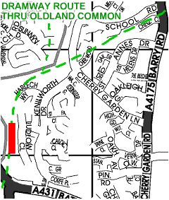
The main dramway
then follows a clearly defined path behind the shops
and houses on the east side of the High Street Oldland.
|
|
|
Tunnel indicated in red
|
It recrosses at an angle just south of School
Road, resulting in one or two odd shaped gardens.
The dramway then goes into a cutting, on under the
now disused railway and into Willsbridge Valley.
An inclined plane
from California Pit joins the dramway just above
where the old millpond used to finish. There is
a substantial bridge over the
brook. (now just a footpath) built
to allow the spur's connection.
After
skirting the valley the dramway again enters a steep
cutting before disappearing into Willsbridge tunnel
which is over 100m long (it was used as an airaid
shelter in WW2).
|
Both
approaches to the tunnel are now fenced off
(PRIVATE PROPERTY - BRISTOL WATER) The tunnel runs
under a private meadow.
Now, by a mixture
of cutting and embankment it heads towards the river
dividing into two en route.

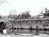
Evidence of the
route south of the A431 can be seen by the weigh-house where the
Keynsham Road and Bath Road connect. Here coal was
sold.
(see above image) The tree shown is growing
where track used to run.
| Avonside Wharf
contains much more evidence: the company house,
blacksmiths and stables, dram repair shed, weighbridge
house and the drivers’ messroom – an upturned tiled
barge, survive.
The dramway was
in fact owned by the Kennet and Avon Canal Company, track
materials were moved to the canal when the
dramway closed.
|
|
Remnants
of the track can still be seen along
the canal today, used as supports
for dam logs amongst other things. Rail plates
sometimes appear in fences as support.
|


